
Multi-Camera Tracking
CAI revolutionizes spatial information through AI technology.
Utilizing existing CCTV without additional markers or sensors,
our solution employs deep learning to achieve real-time location measurement and object detection.
By analyzing the environment, it recognizes objects within the
space and measures distances between individual entities.
To enhance accuracy and repeatability,
we continuously gather and train with learning data, elevating engine performance.

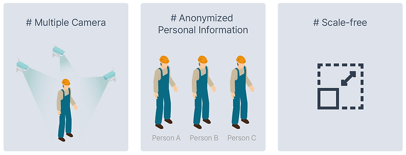
Diverse angles, elimination of blind spots, partial body estimation analysis
Storing personal information
in an anonymized manner
Quantifying location information for real-time integration with external systems
Multi-camera Analysis
You can simultaneously connect from 1 to a maximum of 16 cameras in parallel.
It recognizes tracking subjects as a single object,
enabling comprehensive area analysis without blind spots.
![[ENG]파이미디어랩_IFA Leaflet_v.99.png](https://static.wixstatic.com/media/4d7264_bb3e47c6965f469a90e1dce6736364ca~mv2.png/v1/fill/w_684,h_412,al_c,q_85,usm_0.66_1.00_0.01,enc_avif,quality_auto/%5BENG%5D%ED%8C%8C%EC%9D%B4%EB%AF%B8%EB%94%94%EC%96%B4%EB%9E%A9_IFA%20Leaflet_v_99.png)

Identification of worker’s zone

Measurement of distance between workers and objects

Alerts upon entering hazardous areas

Recognition/discrimination using body parts

Tracking of worker movement paths

Heatmaps based on worker movement paths
Build Smart Factory

01
02
03
World-class Recognition Performance
Trained with 600,000+ real-world training data, it supports world-class recognition performance. As a result, even when only parts of a worker's body are visible, it can recognize them, addressing blind spots and on-site situation issues.
Unlimited Space Measurement
By exponentially expanding the number of cameras, you can eliminate blind spots in the area and enhance object tracking accuracy.
Real-time Additional Learning
Generating additional training data to adapt to daily changing on-site situations, we maintain optimal conditions and accuracy.

CAI system
The Competitive Edge of Cai Location
The technology developed by PAI Media Lab
addresses obstacles that are challenging for a single camera to detect,
as well as the ability to detect objects within
complex structures andaccurately position them.
This is achieved through IPM (Inverse Perspective Mapping) and Calibration techniques,
enabling the transformation of fragmented images acquired from camerasinto a panoramic view. This patented technology models the area of interest, allowing precise measurements.
![[ENG]파이미디어랩_IFA Leaflet_v.99.png](https://static.wixstatic.com/media/4d7264_717b90fe815b4615b87c0cdae7cf30bb~mv2.png/v1/fill/w_728,h_356,al_c,q_85,usm_0.66_1.00_0.01,enc_avif,quality_auto/%5BENG%5D%ED%8C%8C%EC%9D%B4%EB%AF%B8%EB%94%94%EC%96%B4%EB%9E%A9_IFA%20Leaflet_v_99.png)
Benefits of Adoption
![[한글]파이미디어랩_IFA Leaflet_v.99-06.png](https://static.wixstatic.com/media/4d7264_3b471d988dd64b31b200614981428676~mv2.png/v1/fill/w_68,h_76,al_c,q_85,usm_0.66_1.00_0.01,enc_avif,quality_auto/%5B%ED%95%9C%EA%B8%80%5D%ED%8C%8C%EC%9D%B4%EB%AF%B8%EB%94%94%EC%96%B4%EB%9E%A9_IFA%20Leaflet_v_99-06.png)
Affordable Initial Implementation Cost
No need for costly AI server setup, reducing initial expenses by 1/3
![[한글]파이미디어랩_IFA Leaflet_v.99-07.png](https://static.wixstatic.com/media/4d7264_8b114b4dc4d141b3970c462be6c36c74~mv2.png/v1/fill/w_71,h_76,al_c,q_85,usm_0.66_1.00_0.01,enc_avif,quality_auto/%5B%ED%95%9C%EA%B8%80%5D%ED%8C%8C%EC%9D%B4%EB%AF%B8%EB%94%94%EC%96%B4%EB%9E%A9_IFA%20Leaflet_v_99-07.png)
Easy Installation
and Operation
Supports dedicated interfaces for wireless network setup and monitoring
![[한글]파이미디어랩_IFA Leaflet_v.99-08.png](https://static.wixstatic.com/media/4d7264_21ae0fc0553d466d906d912d9547cee7~mv2.png/v1/fill/w_72,h_61,al_c,q_85,usm_0.66_1.00_0.01,enc_avif,quality_auto/%5B%ED%95%9C%EA%B8%80%5D%ED%8C%8C%EC%9D%B4%EB%AF%B8%EB%94%94%EC%96%B4%EB%9E%A9_IFA%20Leaflet_v_99-08.png)
Various
Reporting Features
Reports statistics data such as personnel location, heatmaps, people counting, and weekly/monthly trends
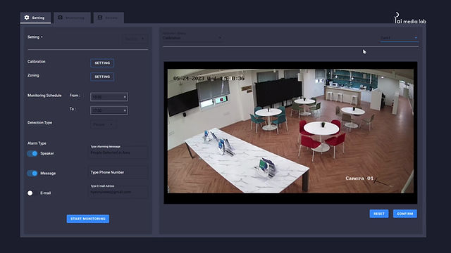
System Demo
Real-time streaming using general FHD-level CCTV to analyze the target and measure the location
(average analysis speed 0.01 sec, measurement error 0.1 m, measurement range, 12 m x 10 m)
Wildlife Detection AI Algorithm
Wild animal recognition deep learning algorithm module based on R-CNN
Coordinates, relative distance, and heat map reporting for each recognized object
Recognize semantic segmentation and classify objects
- Minimize false positives by applying Denoising / Background Subtraction technology

# Real-time detection in wildlife recognition system using our engine screen
Solution Application History


KOREA ELECTIR POWER CORPORATION
Object Recognition Algorithm within the Safety Reporting App / 2020.09
KOREA Railroad
Wildlife detection AI algorithm / 2021.03 ~
KT
Smart Building Disaster Prevention Algorithm / 2021.07 ~
HYUNDAI MOTOR GROUP
Worker Location Tracking Algorithm / 2021.09 ~
Solution inquiry: bsyeo@peoplei.kr